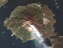
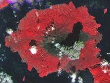
High resolution (HR) and very high resolution (VHR) satellite imagery can reveal a lot more information to help government, organizations and businesses better understand their area of interest and its surroundings to facilitate planning, analysis and decision making.
High resolution and very high resolution satellite imagery have changed the way geospatial industry operates. Such imagery can provide a great deal of visual details and spectral information that have become one of the core inputs to a wide range of GIS or geospatial applications.
High Resolution (HR) and Very High Resolution (VHR) Satellite Imagery
GEOPeakk also markets high resolution (HR) and very high resolution (VHR) satellite imagery products for various remote sensing (RS) and geographic information systems (GIS) applications. Some of these applications include Urban Planning, Forestry and Environmental Management, Mapping, Transportation Systems & Network Planning and Management, Telecommunications, Defense and Intelligence, Homeland Security, etc.
With high and very high resolution satellite imagery products, our users will be able to perform detailed spectral band analysis, feature extractions, change detections and a host of other image processing activities to compliment existing information and geodatabases that they collected and updated overtime. With the ever changing landscape, new and updated information extracted from such satellite images will greatly enhance and compliment existing information to meet the challenging and ever demanding geospatial operational requirements.
Useful Resourses (.pdf):
RapidEye is now Blackbridge (Press Release)
Blackbridge SARL EULA (Legal)
EyeFind™ User Guide (Manual)
RapidEye High Resolution Satellite Imagery (Brochure)
RapidEye Mosaics™ (Brochure)
RapidEye Satellite Imagery Product Specifications (Product Specifications)
RapidEye Mosaics™ Product Specifications (Product Specifications)
The RapidEye Red Edge Band (Whitepaper)
Spectral Response Curves of the RapidEye Sensor (Whitepaper)
Apparent Cloud Shift in RapidEye Image Data (Technical)
RapidEye Image Product Metadata Changes & Addition of the 1B GeoTIFF Format (Technical)